The Buell Graduate Fellowship is an annual award for historical research on the built environment, including but not limited to architecture, urbanism, landscape, and the building sciences.
Awards are given annually for the purposes of facilitating primary research in conjunction with a masters thesis or PhD dissertation project. Interdisciplinary or comparative work on the Americas is especially encouraged. Though research may be conducted in a time and manner of their choosing, applicants must be enrolled full-time in a Columbia University graduate school, included but not limited to GSAPP and GSAS, both currently and continuing in the fall. In addition to receiving support for their research, winning candidates will have the opportunity to present their work at a Buell Center-organized event.
Recipients: Caitlin Blanchfield, Hannah Pivo, Yara Saqfalhait
Caitlin Blanchfield, PhD Candidate Architecture
Unsettling Colonial Science: Modern Architecture and Indigenous Claims to Land in North America and the Pacific
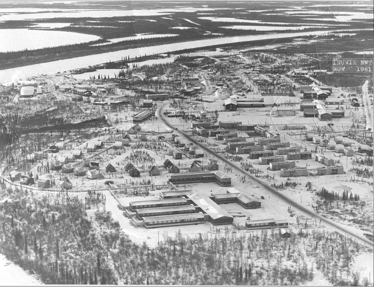
The Buell Graduate Fellowship will support archival and oral history-based research for my dissertation Unsettling Colonial Science: Modern Architecture and Indigenous Claims to Land in North America and the Pacific. This project examines how the settler colonial governments of the United States and Canada have used federally-funded, cold-war era scientific research infrastructures to appropriate Indigenous lands. The research reveals the mechanisms by which settler colonial governance continues and changes through the twentieth century and demonstrates the role of architecture and land use planning in that governance. It also centers Indigenous land use practices as forms of refusal of the settler state, studying land claims, legal cases, and protest movements as expressions of Indigenous sovereignty on contested lands. It does this at three sites: the Kitt Peak National Observatory on the Tohono O’odham Nation in Arizona; the Maunakea Observatories in Hawai‘i; and the Inuvik Research Laboratory in Inuvik, NWT, Canada.
Scientific inquiry has been a means for the state to exert jurisdiction over Indigenous lands at strategic locations and to render so-called wastelands into valuable territories. The observatories and research stations I am studying reveal how US empire operated as an ongoing process of settler colonialism. More importantly they broaden discourses of resistance, showing how material culture, mobility practices, and traditional land use give rise to political movements. Recent scholarship in landscape history has linked Indigenous studies and landscape discourses, my research brings science and technology studies and architectural history to that conversation to show how technology is used to create contested landscapes.

Hannah Pivo, PhD Candidate Art History
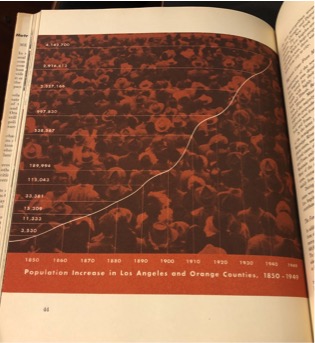
Dots, Graphs, and Pictograms: Social Science, Market Research, and Graphic Design in the United States, c. 1900-1970
This project investigates the relationship between social science, graphic design, and corporate marketing in the 20th-century United States. I explore how design has participated in the transfer of epistemic attitudes, methods, and visual vocabularies between social science and corporations, as designers have borrowed and transformed graphic methods used by social scientists to visualize, disseminate, and instrumentalize information about people and populations into means of representing and shaping consumer behavior. Graphic methods have been integral to studying social bodies since “society” and “the social” became objects of study in the 19th century, as maps, graphs, and other tools were used to render visible—and thus knowable— these emergent concepts. Such efforts resulted in a recognizable graphic language for social science by the early 20th century, with dots, maps, graphs, and pictograms coming to represent not just the so-called “social facts” they visualized, but also the epistemic authority that the disciplines themselves had garnered by this point. At the same time, marketing professionals began to look to social science, adapting certain methods for their own aims of market research. I contend that graphic methods played a less direct— but no less significant— role in the transfer of knowledge between social science and corporations in this period. To unpack these relations, I examine ways in which designers encountered the discourse and methods of social science, especially design education and engagement with the publication of social scientific information—from book and magazine covers to the production of statistical graphics for general-audience publications.

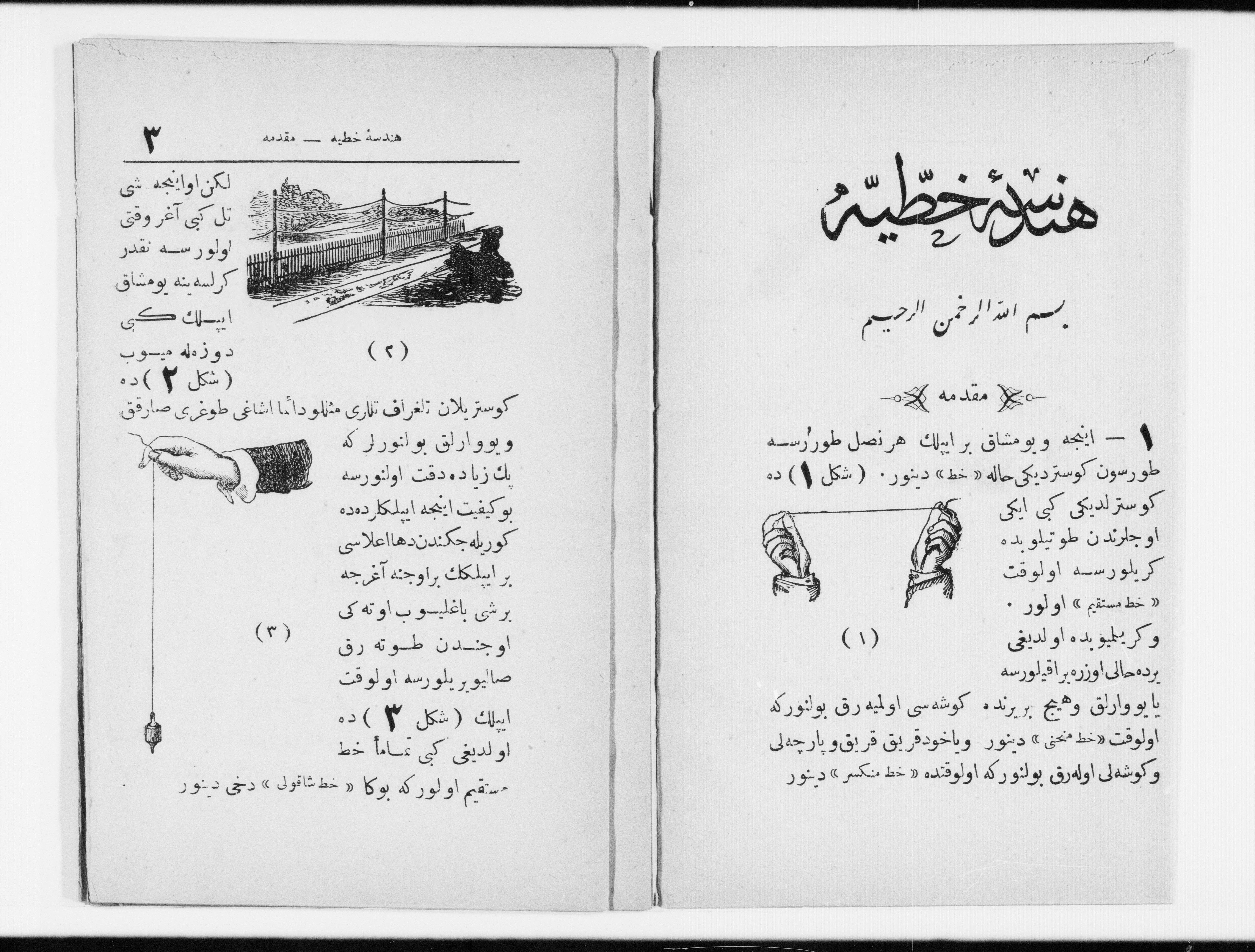
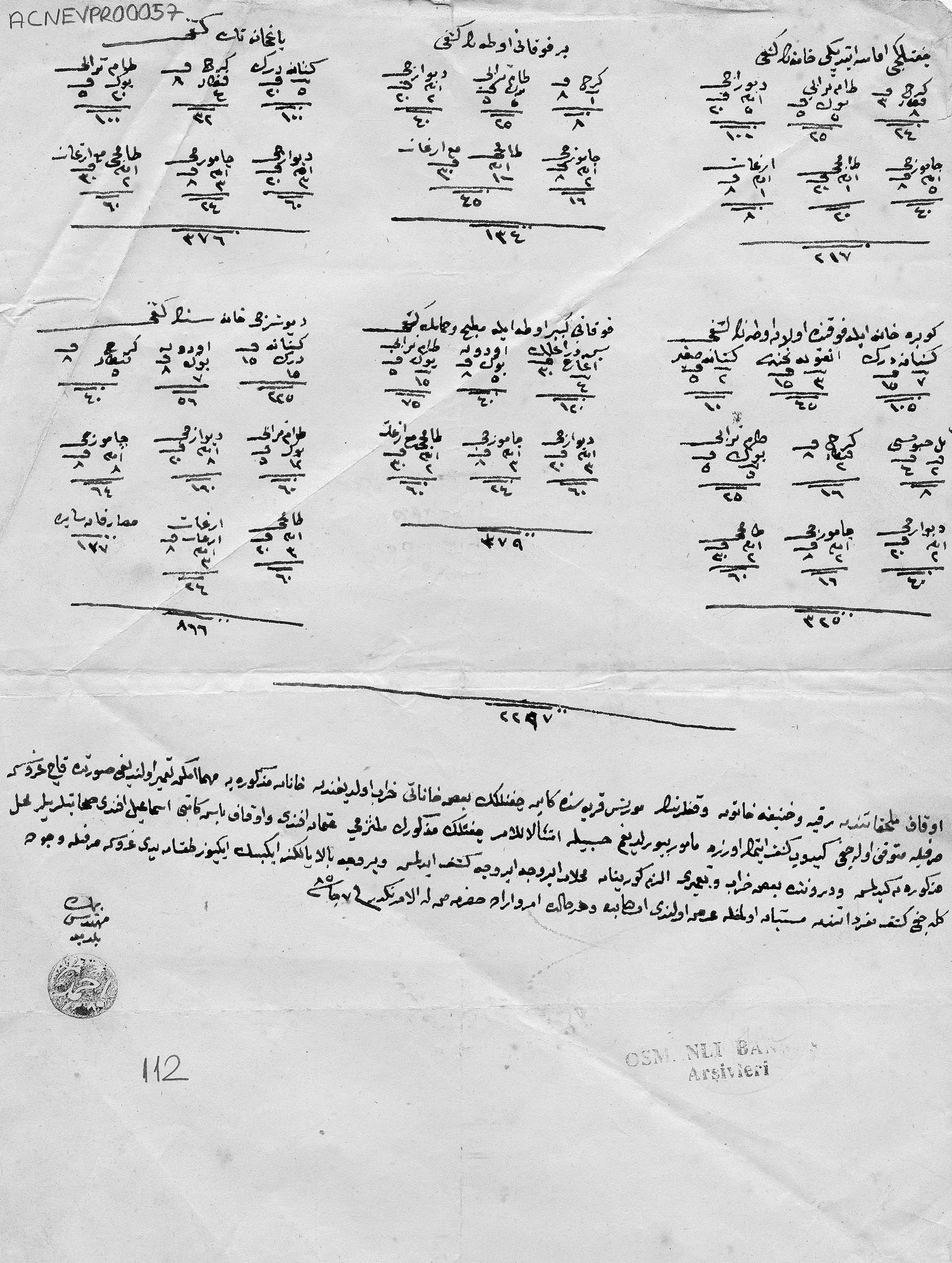
Yara Saqfalhait, PhD Candidate Architecture
Tools of Trade: Architecture, Applied Knowledge and Capital in the Ottoman
Empire 1830s – 1880s
My project examines the relationship between transformations in architectural knowledge and practice in the nineteenth-century Ottoman Empire and simultaneous processes of administrative centralization and economic liberalization. I will trace the interrelatedness between changes in knowledge categories, building networks, trade relations, and modes of quantification and valuation across the empire by following the development and employment of specific technical tools: textbooks of applied mathematics taught in architecture and engineering schools, conversion tables used in construction as well as wholesale commodity markets, the munakasa (tender contract) which made winning bids contingent on a thorough knowledge of the building market and an ability to estimate needed labor, building materials and their value, and the waqfiyya (pious endowment certificate) which relied on different surveying techniques and modes of abstraction and quantification to establish its evidentiary claims for the assets (land, buildings, cash, among others) whose endowment it verified. While each of these tools has its own specific history and modes of operation and circulation during the time period under study, collectively, they weave together dispersed sites of learning and practice that extend beyond the school and the construction site. My research explores how changes in construction operations in the nineteenth-century Ottoman empire were mediated by existing bureaucratic mechanisms and modes of quantification and valuation used in the administration of fiscal revenue. I argue that architects and engineers served as important interlocutors in mediating the changing relationship between capital and labor in the nineteenth-century Ottoman empire, as they navigated the shifting landscape and structures of their own spheres of operation and influence.